 |
| Goggle Earth Image from 2006. VES 1 is by the church VES 2 further up hill past the exist broken borehole. |

 I do not know how many times I have been to the area around
the Sabon Gari District Church since 2008. The community is on the edge of the
town of Mayo Belwa. But it is not in the Mayo Belwa Local Government Area. They
are in Furfore Local Government Area. Across the highway and down the road a
little way is the Secretariat for the Mayo Belwa Local Government. An easy walk
from this community. But they do not get any services from Mayo Belwa. Furfore
where their local government is located is about an hour by car south of Jimeta
and they are about two hours north and east of Jimeta. Fufore LGA does not give
them much services either.
I do not know how many times I have been to the area around
the Sabon Gari District Church since 2008. The community is on the edge of the
town of Mayo Belwa. But it is not in the Mayo Belwa Local Government Area. They
are in Furfore Local Government Area. Across the highway and down the road a
little way is the Secretariat for the Mayo Belwa Local Government. An easy walk
from this community. But they do not get any services from Mayo Belwa. Furfore
where their local government is located is about an hour by car south of Jimeta
and they are about two hours north and east of Jimeta. Fufore LGA does not give
them much services either.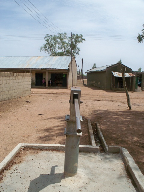
The community got organized and hired a “so called driller” to
drill them a borehole. He did not have a very strong rig and he did not charge
a lot. He drilled down to his limit and had barely hit water. The people talked
him into drilling deeper. After he drilled a little deeper he told them that
his mud pump was not powerful enough to pump the mud out of the hole so he
installed the casing and screen into the drilling mud and left. Long story
short, they went through several “so called drillers” before they finally
agreed to work with the LCCN WASH program and got the pump working. It did not
last long as the pump stand and casing are misaligned and people pump on it from morning into the night.Today they told us that they hired someone from Jalingo in Taraba State to come and repair the pump and it is broken again. Adams and I agree that the rod is probably disconnected from the piston. I am going to figure the cost to put a small borehole pump into the casing that does not matter if it is misaligned. To give them the same amount of water flow as the hand pump which as about all this borehole will produce will probably be the smallest borehole pump made. Since the pump will probably cycle on and off as the water level drops it would waste a lot of expensive fuel to use a generator. A small solar system will make more sense for a daily operating costs.
 We were not in the area today to fix the pump.The community is interested in a second borehole and we had
brought a geologist from the Upper Benue River Authority to do the geophysical
survey to find a good spot for the new borehole. It had rained the night before
and remained overcast to the weather was nice for working. Julius started by
dowsing the area using two wires. If they opened up the water was getting less
and if they closed the water was increasing. He first worked the area around
the Sabon Gari church and decided on a spot. We set his equipment to do a
resistance survey to determine the apparent depth to the water.
We were not in the area today to fix the pump.The community is interested in a second borehole and we had
brought a geologist from the Upper Benue River Authority to do the geophysical
survey to find a good spot for the new borehole. It had rained the night before
and remained overcast to the weather was nice for working. Julius started by
dowsing the area using two wires. If they opened up the water was getting less
and if they closed the water was increasing. He first worked the area around
the Sabon Gari church and decided on a spot. We set his equipment to do a
resistance survey to determine the apparent depth to the water. 
I was first introduced to dowsing in the mid 1980’s when
investigating a grain elevator explosion in southwest Minnesota. A local farmer
informed me that there were old drain tiles running from the building that exploded
out to a creek about a mile away. He grabbed some wire from the rubble and bent
them into an L shape and proceeded to dowse for the pipe. He marked where the
pipe was. I thanked him. Later that evening I took the wires and crossed back
and forth where he said the pipe was and got the same reactions. I figured it
was just my subconscious controlling the wires where the farmer had shown me. I
continued doing cross sections out into the fields and found the outlet of the
pipe about a mile away. Since then I have dowsed for wires and pipes, but I have never tried it for water. For me there was
water everywhere and some areas where they diverged indicating less water. I
would rather review aerial photographs and geological maps. But in built up
areas like this the land has been disturbed and geological features have been
obscured. I have an open mind. I still think there are some clues your mind is seeing in the area that makes you manipulate the wires.


 After the finished the resistance test at the church site, Julius
set out around the community looking for more areas that his wires told him
there was water. He did not get much of an indication and decided on the second
test area after about a half hour of walking around the area. This spot
happened to be near the house of the man that was showing him around. This has
already created talk about “why at his house. Why not at my house”. The second
site is up hill and in from the dirt road that leads through the area. Its main
advantage is that it is up hill. So when you walk to the site with your empty
containers you are walking uphill and then downhill with the full containers. Most
of the community will not have to walk uphill with their full water containers.The
church site will be downhill for almost the whole community.
After the finished the resistance test at the church site, Julius
set out around the community looking for more areas that his wires told him
there was water. He did not get much of an indication and decided on the second
test area after about a half hour of walking around the area. This spot
happened to be near the house of the man that was showing him around. This has
already created talk about “why at his house. Why not at my house”. The second
site is up hill and in from the dirt road that leads through the area. Its main
advantage is that it is up hill. So when you walk to the site with your empty
containers you are walking uphill and then downhill with the full containers. Most
of the community will not have to walk uphill with their full water containers.The
church site will be downhill for almost the whole community.  After we finished the resistance surveys of both sites
Julius choose we were invited by the Water Committee Treasurer to go to Twin
Sisters Restaurant for lunch. They had four tables inside and two on the outside.
The twin sisters are the Treasurer's sisters. I had my regular, rice with soup (red sauce,
spicey, with two pieces of beef). Today they just had rice or pounded rice and soup.The area behind the sisters in where the food is dished up. I think the actual cooking is done out the behind the building where they can hand the food in through the window.
After we finished the resistance surveys of both sites
Julius choose we were invited by the Water Committee Treasurer to go to Twin
Sisters Restaurant for lunch. They had four tables inside and two on the outside.
The twin sisters are the Treasurer's sisters. I had my regular, rice with soup (red sauce,
spicey, with two pieces of beef). Today they just had rice or pounded rice and soup.The area behind the sisters in where the food is dished up. I think the actual cooking is done out the behind the building where they can hand the food in through the window.
As I was typing this into the computer, I was at my desk in the middle of the room under the ceiling fan. A young boy maybe 10 years old yelled from the street "White Man, How are you?" He was more polite than most of the street kids that yell through the fence. I noticed he was selling sachets of cool water. So I walked out to the fence and bought two sachets from him. The water in my frig was colder. so I put his in to cool down and went back to work.


